Central Region Ghost Towns

Hagan

Broken down building at the ghost town in Hagan, NM

HAGAN (East of I-25, east of San Felipe and west of Madrid guided tours only)

Over 100 adobe structures were built by Adobero Abenicio Salazar of Bernalillo with a team of 100 laborers and 60 masons over a period of three years, in the Pueblo Revival style which was popular at the time.


North Central Region Ghost Towns

Cerrillos

Cerrillos Gallery

CERRILLOS (28 miles south of Santa Fe on State Road 14)

The lore of the Cerrillos hills is rich with legends of mines, being worked there for a thousand years. Turquoise has religious significance to many Indian people, nearby Mount Chalchihuitl is known to have contained a great lode of the precious gemstone and stone tools found there seem to testify to the truth of the legends.

Madrid

Madrid NM Ghost town row houses

MADRID (30 miles southwest of Santa Fe on State Road 14)

Although Madrid still likes to consider itself a ghost town, it represents a unique example of resurrection. In the 1920s and 30s, Madrid was as famous for its Christmas lights as for its coal, and airlines used to reroute traffic during the holidays to show passengers the sight. 

Golden

An abandoned house in the ghost town of Golden, NM

GOLDEN (10 miles south of Madrid & 15 miles north of Tijeras on NM 14)

Golden was inhabited by Native Americans and Spaniards long before American settlers came to the area. However, it began to boom when gold was discovered in 1825. Years before the California and Colorado gold rushes, the site of Golden became the first gold rush west of the Mississippi River.

Elizabethtown

A brick house breaking down in the ghost town Elizabethtown, NM

ELIZABETHTOWN (five miles north of Eagle Nest on State Road 38)

Elizabethtown began in 1866 with the founding of area gold mines and the Mystic Copper Mine. It was New Mexico's first incorporated town. 


Northeast Region Ghost Towns

Colfax

The interior of the broken down house in the ghost town of Colfax, NM

COLFAX (15 miles northeast of Cimarron on US 64)

Colfax may be said to have ridden to prosperity on the coattails of Dawson in the late 1890s, when Dawson mushroomed as a coal boomtown. Dawson is dead and gone, but Colfax, however clings to mortality.

Dawson

A mining cart in the ghost town of Dawson, NM

DAWSON (17 miles east of Cimarron on US 64 and A38)

In 1901 the Dawson coal mine opened and a railroad was constructed from Dawson to Tucumcari and the town was born. The Phelps Dodge Company bought the mine in 1906 and increased development.

Loma Parda

The ghost town of Loma Parda in New Mexico

LOMA PARDA (30 miles, give or take north of Las Vegas)

Loma Parda became the town where soldiers could go for wild nights. Saloons, gambling, dance halls and women of ill repute put Loma Parda on the map; especially if you were a soldier bored with your isolated existence at Fort Union.

Montoya

A brick house in the ghost town of Montoya, NM

MONTOYA (Just west of Tucumcari on Old Route 66)

The town of Montoya, in Quay County, was born as a loading point for the Southern Pacific Railroad in 1902. Primarily serving the cattle ranches of the area, an old store, built of solid stone, carried goods and supplies for the villagers.


Southeast Region Ghost Towns

Ancho

An abandoned house in Ancho, NM

ANCHO (24 miles north of Carrizozo, Located west of the Lincoln National Forest 2 miles east of U.S. Highway 54.)

With the arrival of the railway in 1901 and the discovery of gypsum and clay, the Ancho Brick Plant was established and began producing bricks.

Duran

A brick building with boarded up windows in the ghost town of Duran in New Mexico

DURAN (54 miles southwest of Santa Rosa on NM 54)

In February 1902, the El Paso & Northeastern Railroad finished the “Arrow Route,” a stretch of track between El Paso and Santa Rosa, where a connection to Leadbelly’s Rock Island Line awaited. Blas and Espiridón Durán, two brothers, owned wells in central New Mexico which could provide water to railroad work crews. So, the railroad built repair shops and even a wooden roundhouse in what became Duran.

Lincoln

A old building in the ghost town of Lincoln, NM

LINCOLN (57 miles west of Roswell and just south of the Lincoln National Forest.)

Lincoln was at the center of the Lincoln County War, 1876-1879, and is the historical home of Billy the Kid. The village holds an annual festival in August featuring an open-air enactment of The Last Escape of Billy the Kid.

Orogrande

An old mission building in Orogrande, NM

Orogrande​ ( 36 miles south of Alamo­gordo and 49 miles northeast of El Paso, Texas, on U.S. 54.)

Jarilla Junction, once a station on the El Paso and Northeastern Railroad, was renamed Orogrande when a gold nugget the size of a man's finger was discovered in 1905. Prospecting had started as early as 1879 in the Jarilla Mountains but the 1905 discovery started a gold rush and gave birth to the town of Orogrande.

White Oaks

A brick building with bell tower in White Oaks, NM

WHITE OAKS (Three miles north of Carrizozo on US Hwy 54)

Three miles north of Carrizozo on US Hwy 54 is the turn-off to the “ghost town” of White Oaks. White Oaks is not your typical flat-roofed adobe New Mexico historical experience.  It's more cowboy/frontier than adobe Disneyland. There were no Conquistadores bringing the word of God to the native population. It was a frontier wild west cattle community right up until gold was discovered... an almost pure vein going down into Baxter Mountain; then everything changed.


Southwest Region Ghost Towns

Lake Valley

A abandoned vintage car in the desert in Lake Valley, NM

LAKE VALLEY (17 miles south of Hillsboro on State Road 27)

Lake Valley became an important railhead and prospered until the silver panic of 1893. Two or three houses and a few other buildings remain today.

Shakespeare

A bucolic scene in the ghost town of Shakespeare, NM

SHAKESPEARE (3 miles south of Lordsburg)

Now off the beaten track and privately owned, Shakespeare had a tenuous beginning as Mexican Springs in the 1850s as a stop on the Butterfield Overland Stage line. In 1870, prospectors discovered samples of very rich silver ore in the surrounding hills and they went hunting for financing to develop their new mines. 

Mogollon

The Mogollon Theatre in the ghost town of Mogollon, NM

MOGOLLON (9 miles east of Alma on State Road 78)

For nearly 60 years after the great gold strike of 1878, Mogollon had a reputation as one of the most wide-open towns in the West. Butch Cassidy and his crowd were once headquartered there, and gunmen, claim jumpers and gamblers kept things lively. Not even Victorio and Geronimo, nor the troops sent in by the governor, could tame Mogollon. 

Pinos Altos

Horses and riders in front of the Buckhorn Saloon in Pinos Altos, NM

PINOS ALTOS (8.5 miles north of Silver City)

The town began in 1860 when three frustrated 49ers, Thomas Birch, Colonel Snively and another guy named Hicks, stopped to take a drink in Bear Creek and discovered gold. Word spread like wildfire, soon there were over 700 men prospecting in the area. 

Engle

The Schoolhouse in the ghost town in Engle, NM

ENGLE (17 miles east of Truth or Consequences on NM51)

Engle began in 1879 as a stop on the Atchison Topeka Santa Fe Railroad where it was a crucial shipping point for miners and prospectors and served as a water stop. 

Organ

A building with a sign for "SANDWICHES. LUNCHES. BEER. DINNERS." in Organ, NM

ORGAN (14.5 miles NE of Las Cruces)

The once initial mining camp of Organ was officially established as a community back in 1883, though there had been mining activity since the late 1840s. The town's greatest population was around eighteen hundred at the turn of the century. 

Kingston

The Percha Bank in the ghost town of Kingston, NM

KINGSTON (26 miles west of I-25 take exit 63 onto NM 152)

Kingston’s history is a tale ripped from the pages of a western novel.  Geronimo’s Apache tribe once roamed the rugged and beautiful Gila wilderness, including the lush creek-fed valley where Kingston was founded. 


Southwest Region US Route 60

Magdalena

The corner café in Magdalena, NM with signs for ice cream and a book sale

MAGDALENA (28 Miles west of Socorro on US Route 60)

Magdalena was known as the "Trails End" for the railroad/spur line which was built in 1885 from Socorro to Magdalena to transport the cattle, sheep wool, timber and ore.

Pie Town

Pie Town Café in the ghost town of Pie Town, NM

PIE TOWN (84 Miles west of Socorro on US Route 60)

Pie Town is located along U.S. Highway 60 in Catron County. Its name comes from an early bakery for making dried-apple pies that was established by Clyde Norman in the early 1920s.

Kelly

Mining equipment in the ghost town of Kelly, NM

KELLY (South of Magdalena off of US 60, ask locally for directions)

The last residents of Kelly departed in 1947, and most of their homes were painstakingly hauled down to Magdalena.


Southwest Region, Mining District Ghost Towns

Chloride

A broken down brick house in the ghost town of Chloride, NM

CHLORIDE (5 miles southwest of Winston off State Road 52)

The history of Chloride reads like the script for a bad western – silver strike, population boom, Apache raids, salvation by the militia, cattle versus sheep, tar and feathering, even bear attacks. An Englishman named Harry Pye was delivering freight for the U.S. Army from Hillsboro to Camp Ojo Caliente in 1879 when he discovered silver in the canyon where Chloride is now located.

Hillsboro

Buildings in the ghost town of Hillsboro, NM

HILLSBORO (18 miles west of I-25 take exit 63 onto NM 152)

Hillsboro was founded in April 1877, when two prospectors discovered a series of gold deposits on the east side of the Black Range Mountains along Percha Creek. Dave Stitzel and Daniel Dugan staked out the Opportunity and Ready Pay mines. A tent city quickly filled with over 300 miners, store owners, adventuresome women and children.

Monticello

The road in the ghost town of Monticello, NM

MONTICELLO (25 miles NW of Truth or Consequences )

Located along New Mexico Highway 142, Monticello was originally named Canada Alamosa Spanish for "Canyon of the Cottonwoods" and was first settled by ranchers and farmers in 1856.  The town was renamed in 1881 by its first postmaster, John Sullivan, of Monticello, N.Y.

Hanover/Fierro

Mining equipment near Hanover and Fierro in New Mexico

HANOVER/FIERRO (8 miles north of Bayard on NM 536)

Mining was mainly Zinc and the big business was the Emerald Zinc mine built during World War I. Copper mining also took place here. Much of the mining shut down for good in the 1970s. Many residences and buildings are scattered throughout the trees and lining the Hanover Creek bed. It is difficult to tell when you have left Hanover and reached Fierro.


Printable Ghost Town Map

New Mexico Ghost Towns Map

Click on the image to download a printable PDF map of the Ghost Towns featured on the Ghost Towns Trail. Note: the map will open in a new window. To download the map right click and save to your computer. The map is 2.5 MB.

Keep in mind some of the towns mentioned on the map and trail are in remote locations. You should always check locally for weather and road conditions before heading out. Some locations will not have cell phone coverage. Finally please note this map is for entertainment purposes, town locations are approximate. Please observe all signage and ask permission before entering private property.


Read more about ghost towns in New Mexico Magazine

Good Haunts, Ghost Towns on New Mexico Magazine

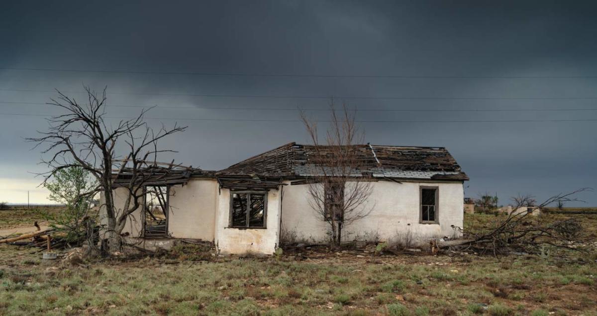
Abandoned, barely there, or rebounding with new purpose, towns, hotels, and restaurants all across the state hold secret treasures: the stories of past lives.

New Mexico Ghost Towns

Good Haunts

magazine logo 80