
Above: Kasha-Katuwe Tent Rocks National Monument. Photograph by Douglas Merriam.
KASHA-KATUWE TENT ROCKS NATIONAL MONUMENT
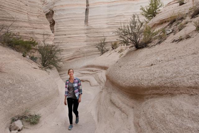
Location: 40 miles west of Santa Fe
The trails at Kasha-Katuwe Tent Rocks wander amid a forest of hoodoos. The three-mile Slot Canyon Trail slices into the dun canyons’ banded and pocketed walls. Flat slabs and rocks perch atop the hoodoos, the cone-shaped formations that give the monument its name. The nest of strange shapes and the rocks that abruptly emerge from the surface are the result of volcanic ash deposits stacked on top of one another, which water then eroded. This hike has some slightly gymnastic squeezes and scrambles, moments when it tucks under a tree trunk or a boulder braced overhead. Then it climbs steeply to an overlook with a view of the cacophony of hoodoos below, the Ortíz and Sandía peaks to the south, and red mesas to the north.
Hikers who’d prefer to skip the steep steps and hands-on scrambling can choose the easier 1.2-mile Cave Loop Trail, which tours through piñon and juniper and past the shark fins of spires to reach a dwelling that Ancestral Puebloans carved into the stone during centuries past.
Pro Tip: Check the website or call ahead. Cochiti Pueblo regularly holds ceremonies at the site, during which it closes to the public.
Length: 1.2 to 3 miles
Cost: $5 per vehicle
Info: nmmag.us/tentrocks
CAPULIN VOLCANO NATIONAL MONUMENT
Location: 30 miles east of Ratón
From the summit of Capulin Volcano, the landscape looks to have been poured into place. Years of lava built up the Raton-Clayton Volcanic Field, where more than 100 other features punctuate the horizon—cinder cones, domes, tuff rings, pressure ridges, lava flows, and this Sierra Grande andesite-shield volcano. It seems all the more improbable, given the chaos of uneven heaps, that this cone emerged so pristinely shaped, like an arrow toward the sky.
Park in the lot at the top and take off from there on the Crater Rim Trail, which encircles the crater. The paved one-mile loop rolls up and down, steeply in sections. The Vent Trail is a spur that carries you to the bottom. Pause for a breather at signs that point out the blue ridges of Colorado’s Rocky Mountains, as well as pieces of Oklahoma, Kansas, and Texas. Drive back down and stop for a picnic at one of the tables near the visitor center.
Pro Tip: The International Dark Sky Association puts Capulin in its gold tier for its caliber of astral viewing. On September 23, 5:30–7:30 p.m., you can safely look for sunspots and other phenomena during its Solar Sunset event.
Length: 1 mile
Cost: $15 per vehicle
Info: nps.gov/cavo
SITTING BULL FALLS
Location: 40 miles southwest of Carlsbad
A two-lane highway guides you through sagebrush fields and ranchland and finally into a hidden canyon. From the parking area, where you can lunch under cabana-shaded tables, a paved pathway traces a streambed that’s usually dry, except during summer monsoons. Round a corner and an entirely different ecosystem splashes into view. A 150-foot waterfall tumbles from the canyon rim, alongside dripping cliffs stained dark by perpetual flow, which feeds a hanging garden of ferns and moss. Stairs descend from a viewing platform to the water, so toes can dip and kids can wade. “‘The oasis in the desert’ best describes it,” says Gordon Martin, who oversees the recreation area as district ranger for the Lincoln National Forest.
Pro Tip: The more adventurous can take a one-mile dirt path that ascends the canyon wall to reach the springs and the source of the water below, or continue on to the newly dedicated Guadalupe Ridge Trail system, which extends over 100 miles all the way to Texas.
Length: mile to 16 miles
Cost: $5 per vehicle
Info: nmmag.us/sbfalls